
Last year we gave you an app to turn back time. A virtual ‘time machine’ on your smartphone or tablet device to let you see what used to be at various locations across Hull and East Yorkshire, using historic photos. Pretty cool stuff – but what if we told you that was only half the story? What if there was another dimension to your virtual time-travel experience that we’ve been keeping a secret?…
Until now, the ‘What Was Here?’ app has let you see through to the past of your surroundings from where you’re standing, but now you can also see that past from a bird’s-eye perspective…with historic maps!
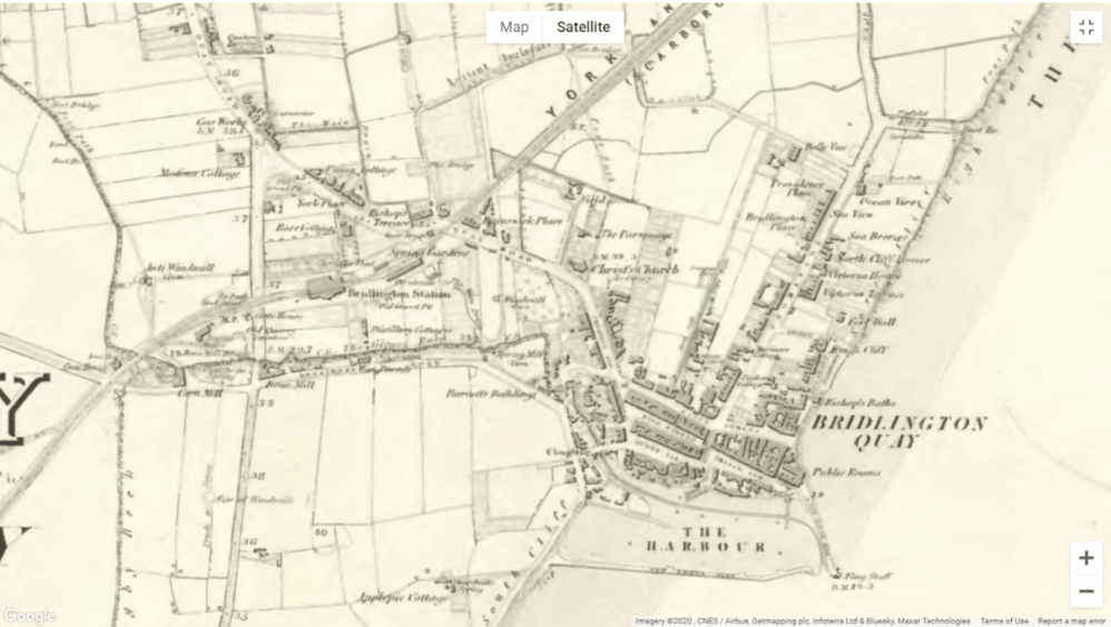
In ‘Back To The Future’, Marty McFly and Doc Brown did a lot of travelling back & forth to the year 1955 on their adventures. For ‘What Was Here?’ we’ve gone back 100 years earlier to 1855 to bring you a map of Hull and the East Riding, superimposed onto a modern Google Maps base-map.
This lets you go back and forth from the present day to 1855 across the whole region using a special ‘opacity slider’. Whether it be ‘what was here’ before Princes Quay, Ferens Art Gallery, or the KCOM stadium; ‘what was here’ before Bridlington Spa, or ‘what was here’ before Flemingate shopping centre in Beverley; we’ve got your patch covered in 1855 (using historic Ordnance Survey maps from East Riding Archives). There’s also the added bonus of York being included too.
It’s taken a while to get these maps onto the platform, but now they’re here in addition to the historic photos, we’ve doubled the fun of the app experience, and it’s such a pleasure to be able to offer this new element to the public.

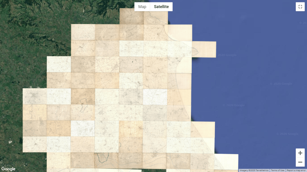
It’s not just 1855 either, the new ‘Historic maps’ timeline goes back even further with whole region maps for 1832, 1793, 1763, 1686, and 1610 (although these obviously don’t compare in as much detail with the present day). So-called ‘Enclosure’ maps from the 1700s and 1800s are also on there:
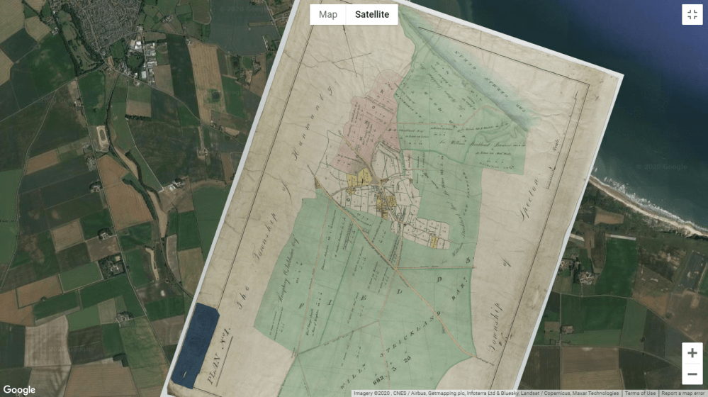
Hunmanby Enclosure Map (early 1800s) 
Hunmanby Enclosure Map (mid-transition)
These were small surveys of the rural landscape and although only a few areas are currently included, this will be the first time many people have seen this kind of map, as you’d normally need to pay a visit to the Archives.
It’s a fact that’s especially satisfying for me because one of the central themes of ‘What Was Here?’ since its conception in June 2015 has been to export archive material beyond the physical barrier of the repository and out into the wider world via mobile devices (see Archivoz 16th Oct 2019 ).


At this year’s ‘Remarkable East Yorkshire Tourism Awards’ (REYTAs), ‘What Was Here?’ was nominated ‘Finalist’ in two categories: ‘Remarkable New Tourism Experience of the Year’, and ‘Remarkable New Tourism Business of the Year’. At the time of writing, we’re now in English Tourism Week and, as with everything else, the tourism industry has been hit hard by COVID-19, with everyone having to adapt and many traditional visitor destinations unable to function as normal.
In times like these, when social distancing is vital for us all, the ‘What Was Here?’ app puts the heritage tourism experience onto our personal devices, removing the necessity for interaction with others, and so giving users a way of exploring an area responsibly through social distancing, (provided of course, that they respect Government guidelines at all times).

It may be that you want to add a general ‘past perspective’ to the place you’re in, or you might be making a more personal, family history, journey by doing some ancestral tourism and visiting the places where your ancestors used to live (in my last post ‘Risk It For A Biscuit’, I mentioned my Hull ancestors had a flour mill on Holderness Road; well, I found it on the ‘What Was Here?’ 1855 map!).

The opportunities for self-directed exploration with the app also offers health and wellbeing benefits and I would encourage people to use it to add interest to and/or inspire a walking or cycling activity.
Exploration of the past through the physical environment can also be a stimulus for reminiscence therapy in dementia sufferers, and the added cognitive element that the app brings to your experience of a place can be equally stimulating for a vulnerable adult to enjoy with their carer, or disability groups coordinating a visit to one of our East Yorkshire towns.

A map-making ‘mountain range’: the story of the overlays…
There’s something particularly rewarding in knowing that you’ve enabled access to useful and interesting heritage content that will benefit someone who may otherwise never have been aware, nor discovered that content’s existence. Even more so, when you consider that some of those people will be vulnerable adults, living in isolation, or with disabilities and/or care needs that prevent or create deterrents to making a physical journey to our facility at the Treasure House in Beverley.

The ‘journey’ in terms of overlaying the historic maps onto the app’s platform and getting a satisfactory UI/UX has not been an easy one in itself though. In fact, it’s been a technical mountain range!
At the beginning of development, I’d assumed (perhaps naively) that the developers would have a pre-set system for tiling the maps and identifying relevant coordinates for plotting the overlays for Ordnance Survey maps and other content. All I would need to do is supply them with the raw materials, right? This was not the case.

It became apparent, almost immediately, that I would need to find those coordinates myself in order for the developers to then work on automation of the map tiling. Attention to detail here was key in order to achieve the best possible past/present comparison for the user experience.
I was pleasantly surprised by the earlier (pre-Ordnance Survey maps) as I was able to get more accurate overlays than I’d expected. This is credit to the contemporary cartographers and surveyors, who would have had only basic tools at their disposal but managed to create maps that still hold up fairly well when laid over Google Maps. Even the rather crude regional maps of the 16th century bare some resemblance to the actual geographic outline, which is very impressive when you think about it.
What was clear from doing these overlays was that all of the historic map images, including the Ordnance Survey to a small degree, required a certain amount of rotation in order to fit properly over the modern base-map. This seemed fine, until I learned that Google Maps does not support rotated images! It automatically adjusts the image onto an ‘X’, ‘Y’ axis.
Our problems were further compounded by severe issues of lag in the load time of the maps, particularly the composite of 1855 Ordnance Survey maps, which created a complete block on the usability of the interface. It may not surprise you then to learn that when it came to soft launching the app in April 2019, followed by full launch in June that year, with historic photos only, it felt at that point as if the maps might never make it onto the app’s front end.

However, this actually worked to our advantage in marketing and publicity because we were able to give intensive focus to the photographic element and heritage trails, with detailed attention on the ‘Camera View’ functionality for past/present (‘now’ & ‘then’) comparisons. Having to publicise the map overlays at the same time may in fact have complicated the marketing message and created confusion. That’s what I call a happy accident!
As we moved into 2020, the developers were doing sterling work on the lag issues, and I’d obtained coordinates for around 100 maps for baseline content (although they still needed some refinement). Then COVID-19 arrived…
As I packed my PC into the back of the car and left the Treasure House in Beverley to enter lockdown under ‘Work From Home’ conditions out in the Yorkshire Wolds; I wondered whether it would even be possible now to complete this work remotely, using the data-heavy map images. I wasn’t even sure I had everything I needed with me at home, and it seemed a distinct possibility that the maps element would now be thwarted by a global pandemic.

Fortunately, this wasn’t the case, and from my ‘work from home office’ (i.e. kitchen & living room) I was able to make the final adjustments to the map overlays and, together with the developers, bring it home and publish the historic maps onto the ‘What Was Here?’ user interface. As well as a story of persistence from June 2015 to now, I guess this is also a tale of our service’s resilience during COVID-19 and our ability to keep expanding our digital offer.
So while I grab a cup of tea, put my feet up for 5 minutes (and maybe even lay in a darkened room for a while), please do go and enjoy those maps!!
‘What Was Here?’ is free on Google Play Store and the App Store.
There’s also a great experience for desktop PC users available at www.whatwashere.org
More details can be found on the East Riding Archives website under ‘Archives Online’.
By Sam Bartle
Digital Archivist
Twitter: @bartle_sam

hi can I ask how to access it from my PC and not on an app? I would like to look at some maps?
LikeLiked by 1 person
Hi Elaine, yes of course. There’s a desktop version at http://www.whatwashere.org .
LikeLike